Treepedia is a new tool from MIT that uses Google street view to evaluate what the coverage of trees are in specific areas. It lets you know what your neighbourhood is like and doesn’t just bias cities with big inaccessible parks. This means that cities (and people!) can use this tool to find where trees are most badly needed from the perspective of a pedestrian. Trees are more than just pollution-fighters, they make cities prettier and friendlier.
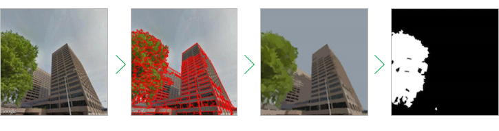
“Street greenery is a really important part of the urban environment,†says Xiaojiang Li, a postdoctoral fellow at MIT who helped develop Treepedia’s Green View Index, a measure of the tree coverage in a city overall and in any area within the city that a user wants to examine.
Trees provide shade for pedestrians in the summer and help to lower urban temperatures, Mr. Li says. They also help prevent water runoff during heavy rain and clean the air.
The MIT team used the Google photos instead of satellite imagery to “really measure how much greenery people might see†as they move around a city’s streets, Mr. Li says. Treepedia’s Green View Index doesn’t take city parks into account for that same reason.
Read more.
Thanks to Delaney!
How do asses enter the arborist equation?
“… Google street view to asses …”
Thanks for catching that!
One of the benefits of being an ass is I recognize one when I see one or more, as the case may be. 🙂